Thursday, May 27, 2010

Italy: a monastery chapel

"Infinite riches in a little room," wrote poet John Donne at about the turn of the 17th century. Many meanings -- primarily, in the poem he wrote, about the beauty of his mistress and how it filled the bedroom they were in together. But with his sensibility about how all things work together ("no man is an island"), he had in mind other ways of packing experience into a single room, a place where we might not expect it.

We walk through Ferrara on a sunny morning, through lanes of old, old houses, brick and stone and tile roofs. Some are inside watching TV (we catch snatches through the shuttered windows next to the sidewalk -- if there is one); many must be off at work or doing the shopping. It's a very quiet morning. Only an occasional bike, and a very occasional car rumbles along these one-lane cobbled streets.

Then a gate near the edge of town, and a small garden of grass and an old tree and some red rose bushes growing the way I'd love to have mine grow at home-- tall and full of blooms. An old portico, and some monuments, and a door that creaks open, opened by a small woman in a nun's habit. She's a Benedictine nun, we know, only because we have read the guidebook about the Monasterio di San Antonio. In Italian, without a pause, she greets us and starts in: we're here to visit, yes? to see the frescoes? follow me.

We walk through a hallway into a chapel. It's not a large room by Italian church standards, and simple. The main ornament are some plaster elements suspended from the ceiling. But there's none of the baroque curlicues, stucco decorations, enormous crucifixion paintings we're used to by now. Mainly white walls, bare floor, and some wooden stalls where the nuns worship. And a dulcimer: one of the nuns must be into new age Catholic music.

The frescoes are in three chapels at the east end of the chapel. The nun shows them to us, narrating them in a quiet voice, almost like a prayer. She tells us of Jesus on the cross, and Saints Benedict and Catherine watching; of the flight to Egypt, with Joseph carrying the baby on his shoulders, and Jesus reaching back to his mother who rides on the donkey; of martyrdoms, St. Stephen patiently being stoned to death, and of the innocents in Bethlehem silently massacred by two fierce Herodian thugs. And with just a little inflection in her almost unwavering recitation, she proudly shows us the wonderful crucifixion where Jesus climbs brave and strong up the ladder set on the cross, a hero rather than a victim.


All I think about convents is overturned here, in this room. This quiet nun, away from the world, is also part of the world. The place itself, unadorned in so many ways, functional for these religious women who pray for the world, is also part of the world. The frescoes make it so: a brutal, tragic, difficult life for people like Joseph, Stephen, Mary, Jesus, exists here too. It is so humanely rendered -- with little touches of humanity and ordinariness -- that the heroism of these stories is more accessible in these small and unassuming chapels than in the grand cathedrals.

I think for a moment of Shakespeare's great play about life in and out of a cloister -- Measure for Measure -- with its intrusion of hypocrisy, lust, and betrayal on a novice who at the start of the play just wants to leave the world behind. (Here in William Holman Hunt's 19th-century painting of Isabella, the novice, with her brother, whose imminent execution is what pulls her out of her isolation). This being (in a strange way) a comedy, it turns out to be a good thing for her that she abandons  her incipient vows and moves towards an apparently richer life (she marries the duke). But we know all the way through the play, that in the convent, too, is infinite beauty in a little room.

Sunday, May 23, 2010

Italy: Bergamo and the layers of history

I like how geography -- so baffling when you first arrive in a place as a stranger -- yields up ideas after a few hours of your putting yourself into it.

We stopped in Bergamo, in the foothills below the Italian lakes. It's a medieval town on a hill, still surrounded by its original walls. It is preserved because the modern town developed on the flat land below and basically left the old town intact. By the 18th century, there wasn't much defensive potential to being up on a hill behind medieval curtain walls, so the point of settling uncomfortably up there was gone. Modern towns needed roads, canals, railways, and room to grow.

The old town is criss-crossed by little streets, no more than alleys, tight canyons of masonry faced by unrevealing little windows and well-locked doors. But then you turn a corner and you're in a piazza; space opens up, maybe just a little; and the buildings open up, too.

You realize, walking these old alleys, why piazzas were so important for the Italians. In the streets, you can't really communicate with more than a couple of others; in the piazza you have room for a crowd. You can throw a party.

The Piazza Vecchia in Bergamo is fairly big, and very communal. On the north are the porticos of the public library; on the west, the entrance to the old university (Bergamo struck us as a pretty studious and serious town). On the east are cafés; we ate lunch at the Caffé del Tasso, "since 1476" (what would they have served then? not espresso, for sure).

On the south, the piazza is bordered by an interesting building, the municipal hall, or Palazzo del Ragion. Above, this is essentially one large room, an amazingly wide and high room with complicated medieval trusses, apparently the place for town debates, policy meetings, banquets, etc. Underneath, at piazza level, is an open portico. Thus you can look right through the building to a smaller piazza beyond. The piazza is both enclosed and permeable at the same time.

What you reach by going through the portico is the religious center of town -- the Piazza del Duomo, with its cathedral as well as a very large Romanesque church of Sta. Maria Maggiore, baroque-ified inside to beat the band. Literally next to this is a third church, a chapel that holds the tomb of Bartolomeo Colleoni, a Bergamasque mercenary mostly working in the pay of Venice. ("Bergamasque" is the adjective form of Bergamo, and became used for a famous Renaissance dance.)

So beyond the portico lie two big forms of organized power - church and army. But back in the big piazza, power seems much more diffused: library, university, commerce, city government with its traditional neighborly squabbles.

In the portico itself, where the city council used to hold hearings, there's a nice reminder of how history changes. In the late 18th-century, some scientifically inclined citizen created a complicated sundial (an "analemma") on the floor, in inlaid pieces of marble. It doesn't tell the time, but the days of the year. Each sunny day at real-time midday (not noon, but apparently 12:21), the sun streams past the cathedral to shine through a hole at the top of one of the arches, and hits a long line in the pavement at some point that tells you what date it is. Aside from being a useful check on the less-than-reliable calendars of the day, it's a visual reminder of the tilting of the earth: in summer, close into the front since the noon sun is high in the sky; in winter, a ray stretching some hundred feet into the portico, since the sun's down near the horizon even at noon.

History layers itself: Medieval (a town walling itself in for its own life in a fierce environment of marauders); Renaissance (Colleoni putting his energy and guts -- sprezzatura, he'd have said -- up for sale to the Venetian Republic); Enlightenment: a rationalist creates a visual emblem of the predictability of Galilean planetary motion.

Friday, May 21, 2010

Italy: the lakes

As we flew south from Dusseldorf to Milan, the thick clouds broke over the Alps, just as we must have passed over the high point of the range, maybe over Piz Bernina. It was stunning to see these peaks, below us but not very far below. The ground, so far away when we were up in the lowlands of the Rhine and Dussel valleys, was suddenly rising to meet us.

The plane followed a valley south from the high peaks, narrow and twisting and with what probably was a torrential stream in the center of it, then gradually widening and including some farmland. We were probably in Italy by then; in a moment we started seeing on both sides of the plane the Italian lakes -- Lago Maggiore and Lago di Como. (I'm writing this on the roof garden of our hotel on Lago di Como, looking north at sunset to the still-glowing Alps.)

Then, as we approached Milan's northern airport, the land flattened dramatically. It was that rich farmland of Lombardy, fields squared off with lines of those dark Lombardy poplars, rich old tile-roofed barns. The fields were flooded: we guessed that it might be the rice fields where that wonderful smooth arborio rice grows that we use for risotto.

Now, spending two days in the lakes, I've been thinking about the relationship of the mountains, the lakes, and the plains. Here is a mountain range that is practically impenetrable, until modern days: where the trucks now cross the St. Bernard pass on an autostrada, until very few years ago there were only winding roads. When Wordsworth walked across the Alps in 1792, there was only a track (and he got lost).

The Alps are the great defense of Italy -- along with the sea that surrounds the rest of the peninsula. They are the divide of the continent, Italy becoming the "Cisalpine" -- below the Alps -- region of Europe.

Then there are the lakes, long north-south lakes carved by the glaciers. They remind me of the other north-south lakes I've been around -- the Finger Lakes of New York, our Lake Dunmore in Vermont, Windermere and Wast Water in the Lake District of England. Going about here in the past two days, I've realized how wonderful they are as highways. Driving around them here is terrible -- narrow roads, suddenly made one-lane by jutting-out corners of houses, twisting and dangerous. But on the lake, in a ferry, you're on the level and in the wide-open spaces.

It's in The Last of the Mohicans that the north south lake of Oswego figures so strongly -- the canoes sweeping down from the north onto the barely-tenable fort at the south end (if I remember it rightly). My image may be wrong, but every time I look up a lake like this of Como to the north, I imagine boats paddled by folks who would rather that they lived in the place that I currently inhabit.

Lake Como is y-shaped like Lake Keuka in New York. At the crucial juncture is the town of Varenna, across from Bellagio where we are staying. Above Varenna, a pretty fierce half-hour climb for us (the guidebook called it "a brisk 20 minutes"!) is the Castello di Vezio: a fortress to defend this lake-highway against marauders. Sometimes thought to be Roman, sometimes Longobardian (that is the name of the post-Roman migrants who settled this area, now called Lombardy after them); certainly it's medieval in the form we saw it, with crennelated battlements, a high watchtower-keep, and curtain walls.

So the Alps, I was thinking, are a great wall to the north. But the lakes are highways that -- if you could breach that wall -- take you right down to the goodies to the south: fields, factories, river power, ports. No wonder you work hard to build a fort like that: you need to keep the access control.

And I was thinking, too, about directionality around here. Does the threat come from the north, usually? I was thinking about Napoleon coming down from Paris to "liberate" Italy from the Austrians (they welcomed that, for a little while). I was thinking about the Emperor Charles V, I think (I don't have internet access, so I can't fact-check very well), rampaging down to sack Rome in the 16th century. And the Germans in the mid 20th century, moving south when their incompetent partner Italy folded, to fortify the Appenines against the Allied advance up the peninsula from Sicily. Maybe even Hannibal, who brought his elephants around from Carthage (through France?) and crossed the Alps south to attack Rome.

Where the threat comes from probably depends on where you are at the moment. If you were a Gaul in 40 BC, you probably saw the threat coming north from Rome in the form of Caesar's army.

Thursday, May 20, 2010

Italy: mapping our flight

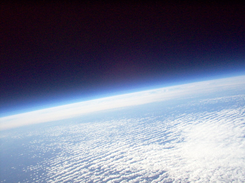
During the night on our flight to Dusseldorf, we hit some rough air and the pilot took us up to 39,000 feet. When the sun came up, i opened the window and saw the curve of the earth, bending down in front of us and again behind us. . It was a gentle curve, not like the beachball rotundity that the astronauts see, but a curve nonetheless. I'm not sure I'd ever been up that high. It made me feel a long way from the ground. (the picture is one from 90,000 ft up, not mine).

As a map fanatic, I like to know where we are while I'm flying. It gives a (fictitious) sense of groundedness, of connection to the real earth, while my suspended life consists of this bizarrre cigar-shaped polystyrene cabin shared with a few hundred others including the screaming 2-year-old in front of me.

Earlier in the flight, while we were still over North America and the sun had not set, something went wrong with the plane's entertainment video system. That meant not only that I couldn't watch episodes of Friday Night Lights, but also that the cool flight map that some flights give you was not working. So, with a lot of cloud cover and only intermittent views of the ground, it was harder than usual to figure out where we were.

At one point, we were launching out over lots of water, with a curving peninsula to the south of us that I thought might be the Gaspé just where the St. Lawrence River meets the North Atlantic. Then the clouds hit again; an hour or so, later we saw ground again that was obviously still the farmland of Canada. The water had been, I'm guessing, Georgian Bay, off Lake Huron. Oops.

Knowing where you are on the map is nice, but the accuracy of that "knowing" really doesn't make any difference, except for the folks in the cockpit.

Eventually, the mapping system was working again, as we ate breakfast over the Irish Sea and started sloping southeast across England. I watched it of course, while also hunting for breaks in the clouds to corroborate what the map was telling me about where we were (as if it could be wrong!).

I love that instant mapping screen. For one thing, I love the stolid repetitiveness of its numbers: distance to destination, 3,204 miles; a few minutes later, distance to destination, 3,125 miles, our inevitable progress (we hope) plotted in sequential announcements, like the daily sextant readings in a China clipper's log book.

I also love the way the screen flips through various views, from local (maybe 500 miles) to regional (maybe 2,000 miles) to global (our plane, a tiny dot, on its trajectory across a screen that flattens the earth, a great ice cap on top and bottom, continents and oceans striping vertically across, and the big waveform that indicates night finally running away from us at 1,000 miles an hour or so.

And I love even more the grounding that comes when I turn from the screen to the window, glance ahead of the wing, and identify the curve of the Norfolk coast as we head across the Channel. [again, not my picture, but it is Norfolk].

Yes, I know where we are! And yes, apparently so does the pilot!